
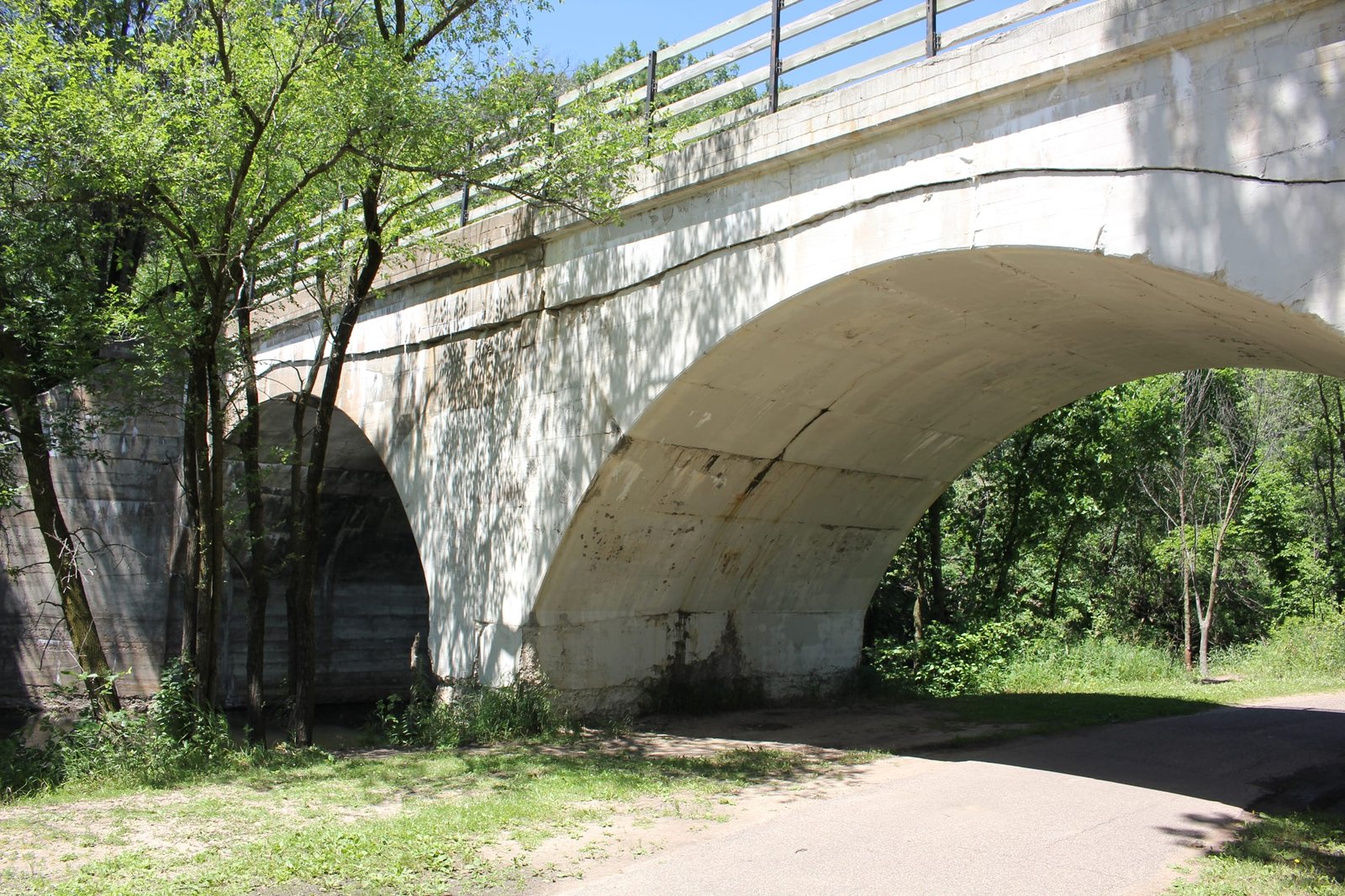


Click the photo to view the full-size version
| Name | Gateway State Trail - Keller Lake Bridge |
| Built By | Wisconsin Central Railway |
| Currently Owned By | Minnesota Department of Natural Resources |
| Superstructure Contractor | Unknown |
| Length | 76 Feet Total, 38 Foot Spans |
| Width | 1 Track (20 Feet) |
| Height Above Ground | 15 Feet (Estimated) |
| Superstructure Design | Concrete Arch |
| Substructure Design | Concrete |
| Date Built | 1906 |
| Traffic Count | 0 Trains/Day (Bridge is a Trail) |
| Current Status | Open to Trail Traffic |
| Significance | Local Significance |
| Documentation Date | 7/2/2017 |
In 1880, the Wisconsin and Minnesota Railroad (W&M) would complete 54 miles of new railroad extending from Abbotsford to Chippewa Falls, Wisconsin. By 1885, 109 additional miles would be completed from Chippewa Falls to St. Paul, Minnesota. In 1888, the W&M would be acquired by the Wisconsin Central Railroad, which would be renamed the Wisconsin Central Railway (WC) in 1899. The WC had previously completed a mainline, extending from Chicago to Abbotsford. In 1909, the WC would be leased by the Minneapolis, St. Paul & Sault Ste. Marie Railway (Soo Line), which itself was controlled by the Canadian Pacific Railway (CP). The Soo Line had constructed a large network of railroads, connecting the Upper Midwest with Canadian Railroads.
In 1910, the WC began a series of projects to reconstruct the route. The largest project was a new 18-mile alignment between Withrow and New Richmond, Wisconsin and the bridge over the St. Croix River, which opened in 1911. This new alignment reduced the amount of grades and curves, and provided a connection to the Soo Line tracks at Withrow. Additional relocations included 19 miles between Owen and Spencer which bypassed Abbotsford, and 11 miles between Colfax and Howard. The old St. Croix River bridge would be scrapped in 1916, the Abbotsford to Curtiss segment abandoned in 1934, and the Curtiss to Owen segment abandoned in 1938. By 1961, the WC, Soo Line and Duluth, South Shore & Atlantic would be merged to form Soo Line Corporation, a holding company controlled by Canadian Pacific Railway. The segment between St. Paul and Carnelian Junction would be abandoned in 1980, and acquired by the Minnesota DNR. In 1984, the Soo Line would be reorganized as the Soo Line Corporation in advance of a pending purchase of the Chicago, Milwaukee, St. Paul & Pacific Railroad (Milwaukee Road).
After the Soo Line acquired the Milwaukee Road in 1986, this route became less important, as the Milwaukee Road purchase provided Soo with additional connections between Chicago and St. Paul. In 1987, the route would be sold to Wisconsin Central, Ltd. Known as the "new" Wisconsin Central, the railroad acquired several excess rail lines from the Soo Line and C&NW, before being acquired as the American subsidiary of Canadian National Railway in 2001. Today, the Gateway Trail utilizes the line between Carnelian Junction and St. Paul, while CN operates the remainder of the line as the Minneapolis Subdivision, part of the principal CN connection between Minneapolis and Chicago.
Located on the east side of St. Paul, this concrete arch bridge carries a former Minneapolis, St. Paul & Sault Ste. Marie Railway (Soo Line) mainline over the channel between Keller Lake and Round Lake. The first bridge at this location was likely a timber pile trestle bridge, constructed when the line was first built. In 1906, the bridge was replaced by a new concrete structure. Currently, the bridge consists of two 38-foot concrete arch spans, set onto concrete substructures and constructed at a width of 20 feet. The superstructure follows a standard design, with two semicircular arches and short headwalls. The substructure also follows a standard design, with a rectangular pier and sloped wing walls which extend diagonally from the structure. It is unclear if the bridge was constructed by an unknown contractor or railroad company forces. Concrete arches became popular for railroad use in the early 20th Century, as they were economical, durable and easy to construct. After the bridge was abandoned, wooden railings were added and the bridge was reused as part of the Gateway State Trail. Overall, the bridge appears to be in poor condition, with shifting, cracking and significant spalling at the joint between the headwall and arch lines on the south face. The author has ranked this bridge as being locally significant, due to the common design.
Citations
| Build Date | Soo Line Historical and Technical Society |
| Railroad History Citation | ICC Valuation Information, Compiled by Richard S. Steele |