


Click the photo to view the full-size version
| Name | Moose Lake Railroad Crossing |
| Built By | Minneapolis, St. Paul & Sault Ste. Marie Railroad |
| Currently Owned By | Carlton County |
| Superstructure Contractor | Unknown |
| Substructure Contractor | Unknown |
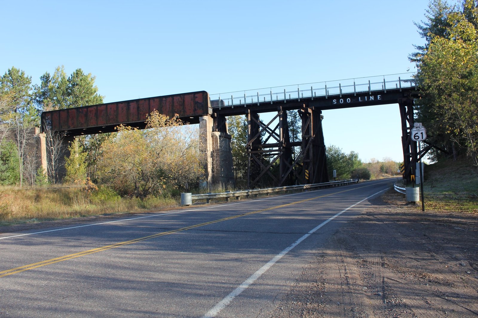
| Length | 204 Feet Total, 80 Foot Main Span |
| Width | 1 Track |
| Height Above Ground | 25 Feet (Estimated) |
| Superstructure Design | Through Plate Girder, Steel Stringer and Timber Pile Trestle |
| Substructure Design | Concrete and Timber Pile |
| Date Built | 1915 (Through Girder) 1940 (Steel Stringer and Trestle) |
| Traffic Count | 0 Trains/Day (Bridge is a Trail) |
| Current Status | Open to Trail Traffic |
| Significance | Local Significance |
| Documentation Date | 10/11/2014 |
In 1907, the Minneapolis, St. Paul & Sault Ste. Marie Railway (Soo Line) began construction on a new railroad line, extending from the existing mainline at Brooten, Minnesota; to the Twin Ports city of Duluth, Minnesota. The first 87 miles were completed by the end of 1908, with the remaining 100 miles completed in 1909. The Soo Line was a smaller railroad in the Midwest, with routes extending through Minnesota, Wisconsin, Michigan and North Dakota. It was operated as a subsidiary of Canadian Pacific Railway (CP). This route became a critical connection for the Soo Line, providing a connection between the existing mainline at Brooten and the industries at Duluth. By 1937, the Soo Line had entered bankruptcy, and it would be reorganized as the Minneapolis, St. Paul & Sault Ste. Marie Railroad in 1944.
By 1961, the Soo Line would be merged with other CP subsidiaries Duluth, South Shore & Atlantic Railroad and Wisconsin Central Railroad to form Soo Line Railroad, a company controlled by CP. In 1984, the Soo Line would be reorganized as the Soo Line Corporation, and the railroad would be fully merged into CP in 1990. The segment from Genola to Superior was abandoned in 1990. The segment from Genola to Boyleston was purchased by MNDOT and Douglas County, Wisconsin and converted to the Soo Line Trail. The remainder of the route would be abandoned in 1996, and purchased by Morrison and Stearns Counties for trail use. Today, much of the route has been converted to the Soo Line Trail, and further work is being done in Stearns County to convert the railroad to the Dairyland Trail.
Located on the north side of Moose Lake, this through girder and trestle bridge carries the Soo Line Trail over the Willard Munger State Trail (former Northern Pacific Railway) and County Road 61 (former US Highway 61). The first bridge at this location was a timber Howe pony truss bridge, constructed when the Soo Line first opened. This timber bridge was intended to be temporary, and timber bridges were often constructed to allow for settling of approach embankments. In 1915, the bridge would be replaced with a 80-foot through plate girder span, set onto concrete substructures. In 1940, the bridge would be extended east to allow for the construction of US Highway 61. This extension would consist of a 30-foot steel stringer span over the roadway, with three timber pile trestle spans on either end. The extension would be set exclusively onto timber pile substructures, and the former east abutment was reused as a pier. Two unknown contractors fabricated the steel spans, and an unknown contractor constructed the concrete portions of the bridge. Through girder spans were popular for railroad use, as they were durable and easy to construct. Steel stringer and timber pile trestle spans were commonly used by the Soo Line, as they were inexpensive. Overall, the bridge appears to be in good condition, with little serious deterioration noted. The author has ranked this bridge as locally significant, due to the common design.
Citations
| Build Date | National Bridge Inventory (NBI) |
| Railroad History Citation | ICC Valuation Information, Compiled by Richard S. Steele |